Acknowledgements
This paper was researched and written by Steven Coutts, with contributions from Merlin Chatwin, Karine Saboui and Sanjida Rabbi.
This research initiative was supported by Esri Canada.
We wish to thank all individuals who participated in this research.
Executive summary
Part 1: Setting the context
Municipalities are the level of government closest to residents. Geospatial data is critical in planning the infrastructure and delivering the services that residents interact with daily. More broadly, sharing geospatial capacity can enable municipalities to collectively address challenges extending beyond any community’s borders.
Yet, the ability to fully leverage geospatial data varies significantly between communities. Collaboration – that is, sharing data assets, infrastructure, and knowledge – can help municipalities to gain capacity they would not otherwise be able to access in order to:
- Improve internal data practices;
- Share collective intelligence and making mutual decisions on issues of regional importance;
- Unlock geospatial information for community-based economic, social, and environmental initiatives;
- Present a united ask for resources from higher levels of government.
Part 2: Mapping the data collaboration journey
The process of embarking on a collaboration is divided into four key stages: Identifying and evaluating the opportunity; Understanding current capabilities; Designing and implementing the collaboration, and; Measuring outcomes and sharing successes. Each stage brings its own set of considerations which are framed as a series of prompting questions for municipal staff:
- Stage 1: Identifying and evaluating the opportunity:
- What are the internal and external drivers of collaboration?
- Who are potential partners?
- Stage 2: Understanding current capabilities:
- What human and technological resources are available?
- What financial resources are available?
- What data is available?
- Stage 3: Designing and implementing the collaboration:
- What form should the collaboration take and how will it be governed?
- What standards, processes, and procedures need to be adopted?
- Stage 4: Measuring outcomes and sharing successes:
- How will progress toward objectives be measured?
- How can partners raise awareness of the collaboration?
Examples of successful collaborations are referenced throughout this section.
Part 3: Conclusion and recommendations
The report concludes with recommendations for several groups of actors – provincial and regional governments, civil society actors, and the private sector – to support municipal geospatial capacity while promoting beneficial collaborations.
- For provincial government actors:
- Develop targeted grant and support programs for building municipal geospatial capacity;
- Invest in high-speed internet infrastructure for rural and remote communities.
- For regional government actors:
- Develop tailored support services, resources and funding opportunities aimed at developing capacity and supporting collaborative activities among lower-tier municipalities.
- For civil society actors:
- Convene forums and communities of practice for municipalities facing similar challenges;
- Create partnerships with municipalities to facilitate mutual learning and capacity-building.
- For private sector actors:
- Develop tailored support services and products aimed at the small, rural, and remote municipal market;
- Demonstrate the value of making key datasets open and available from a public as well as commercial perspective.
Ultimately, there is still much to be learned about how municipalities can collaborate effectively and sustainably, and how non-municipal actors can best support them. It is hoped that the recommendations offered here will catalyze further conversation and research in this space.
Introduction
This report is the result of a joint research initiative between Esri Canada and Open North. The objective of this research was to learn more about geospatial capacity in municipalities across Canada, how they are harnessing this capacity to meet current and future needs, and how collaboration with other municipalities, levels of government, and supporting organizations can help boost municipal capacity.
Previously, the Open North team explored the municipal open data landscape as a means of setting the stage for a collaborative cross-jurisdictional standardization effort on open data.[1] This report advances that call for collaboration as key to building geospatial capacity at the municipal level within the broader context of digital transformation and open government to respond to residents’ needs and address effects of local and global issues.
The project team did not set out to conduct a comprehensive survey of municipal GIS staff; rather the analysis and recommendations in this report have been synthesized from a variety of sources. The project team conducted a targeted review of current literature from both academic and practitioner sources, including valuable documentary evidence of current collaborative initiatives provided by municipal staff. Semi-structured interviews were conducted with eight individuals recruited from a sample of 180 municipal GIS staff contacted through an online pre-screening survey. Interviews were also conducted with representatives of two civil society organizations involved in supporting innovation in Canadian municipalities.
The report contains three parts, the contents of which are briefly summarized here:
- Part 1: Setting the context: The report begins by introducing the importance of geospatial capacity in supporting decision-making and locational intelligence in municipal service delivery and planning. However, this capacity is not evenly distributed among Canadian municipalities, particularly smaller, rural and remote communities. Collaboration between municipalities is one strategy for building collective capacity while addressing shared challenges at a regional scale;
- Part 2: Mapping the data collaboration journey: Next, the process of embarking on a collaboration is divided into four key stages: Identifying and evaluating the opportunity; Understanding current capabilities; Designing and implementing the collaboration, and; Measuring outcomes and sharing successes.
- Part 3: Conclusion and recommendations: The report concludes with recommendations for several groups of actors – provincial and regional governments, civil society actors, and the private sector – to support municipal geospatial capacity while promoting beneficial collaborations.
Part 1: Setting the context
It is often said that municipalities (both urban and rural) are the level of government closest to residents. Indeed, municipalities are responsible for planning, building, delivering, and maintaining much of the infrastructure and services that residents rely on and interact with on a daily basis.
Geospatial capacity supports decision-making and locational intelligence in the context of municipal service delivery and planning, including land use and transportation, infrastructure asset management (e.g., roads, sewers, water pipes), emergency response, public safety, health, economic development, planning, engineering, and more. Over the years, geographic information systems (GIS) have become ubiquitous and have transformed from specialized applications used by dedicated units or departments into general-purpose applications for all staff based on location data.
Geospatial data is playing a pivotal role in the digital transformation of municipalities, as can be seen in the example of York Region’s DATA (Data, Applications, Tools, Academy) Co-op platform, which allows “GIS practitioners from each Regional municipality access and share data, code, technology and training – enabling them to leverage each other’s resources, accomplishments and insights to better meet local needs.”[2]
Bringing together data from across municipal functions in a GIS creates a single source of truth that can be used to provide municipal responses in areas including, but not limited to:
- Climate change mitigation: By forecasting localized climate change impacts (e.g., flooding, forest fires), as well as supporting mitigation efforts such as mapping energy consumption and waste production across the community;
- Sustainable land use and transportation planning: By monitoring urban and rural development, and directing growth in a way that leverages investments in mobility infrastructure and other amenities that enhance the quality of life and mobility of residents;
- Emergency response: By future-proofing critical services and infrastructure (see Box 1: Next-Generation 911 (NG9-1-1)) to ensure there is the capacity to respond to routine emergencies as well as prepare for, respond to, mitigate, and recover from extreme events such as floods, severe weather events and the COVID-19 pandemic.
However, geospatial capacity is not spread evenly among Canadian communities.[3] The size and complexity of a municipality, resources available, and degree of reliance on regional or provincial governments are all factors that impact cities’ capability, opportunity and motivation to collaborate — and will take different forms between large, mid-sized, and small municipalities.
- Large municipalities (serving 500,000 to over 1 million residents) typically have highly mature GIS programs which support a broad range of services and functions. By definition, they sit at the core of metropolitan regions and are well-positioned to initiate and sustain collaborations with neighbouring municipalities due to their significant capacity and resources. Large cities are also seen as innovators – collaboration trends piloted in a large municipality may become a model for other cities;
- Mid-sized municipalities (which can be defined as serving urban areas with a population of 50,000 to 500,000 residents[4]) are likely to have established GIS programs that support services and functions such as urban planning, public works, waste management, and emergency services. While they also could benefit from pooling their geospatial data with neighbouring municipalities, they are also likely to have more limited capacity, resources, and power, which will impact the ways in which they collaborate;
- Smaller municipalities generally have minimal to no in-house GIS capacity. Staff may still be working from paper-based maps, with only some data digitized. Basic GIS services and many of the services and functions that require shared geospatial data may be provided by a local agency (e.g., local planning district) or by the provincial government, thus reducing the need for collaboration with neighbouring municipalities. Challenges can include insufficient resources for training, lack of funding, and limited support for developing and maintaining GIS infrastructure.[5] Rural and remote communities may face the added barrier of low access to broadband internet – necessary for many cloud-based applications and required for efficient GIS data sharing.
The case for collaboration
There are examples to point to where municipalities cooperate with one another to pool their capacity, realize cost savings from economies of scale, fill gaps in service provision, and respond to external mandates.[6] This involves data sharing for traffic management, public transportation, land use planning and development, as well as other core municipal functions that span jurisdictional boundaries.[7] Some of the earliest collaborations involving inter-jurisdictional data-sharing involved GIS – and today integrated spatial data infrastructures exist in many places. But while collaboration between neighbouring municipalities is not a new strategy for meeting the needs of residents, it has yet to become a common practice.
The case for collaboration in geospatial data should be a relatively easy one to make. Residents do not care, for instance, that their daily commuting route crosses municipal boundaries; they simply want to be able to plan their journey from home to their place of employment on public transit. Residents want to know how municipalities are working together to maintain and upgrade infrastructure that is shared between jurisdictions.[8]
No matter where municipalities are in developing their geospatial capacity, there are benefits to be realized through collaboration, including:
- Improving internal data practices: The opportunity to compare practices, along with the degree of standardization and interoperability required for most data collaborations, can provide an incentive to examine and align policies and workflows across departments and business units;
- Sharing collective intelligence and making mutual decisions on issues of regional importance: One of the most obvious benefits of forming a collaboration is the opportunity for municipalities to become more ‘plugged in’ to issues at a regional scale;
- Unlocking geospatial information for community-based economic, social, and environmental initiatives: A regional ‘one-stop-shop’ for open geospatial datasets can help enable informed participation in local issues by residents and support civic tech and entrepreneurial communities in creating new applications and services;[9]
- Presenting a united ask for resources from higher levels of government: A single municipality may face difficulties securing resources to improve its geospatial capacity, but joining forces with other municipalities and presenting a compelling case can convince higher levels of government of the value of their investment.
However, understanding the potential benefits still leaves the question of where municipalities should start when considering a collaboration. The next section will explore four key stages of a municipal ‘collaboration journey.’
Part 2: Mapping the data collaboration journey
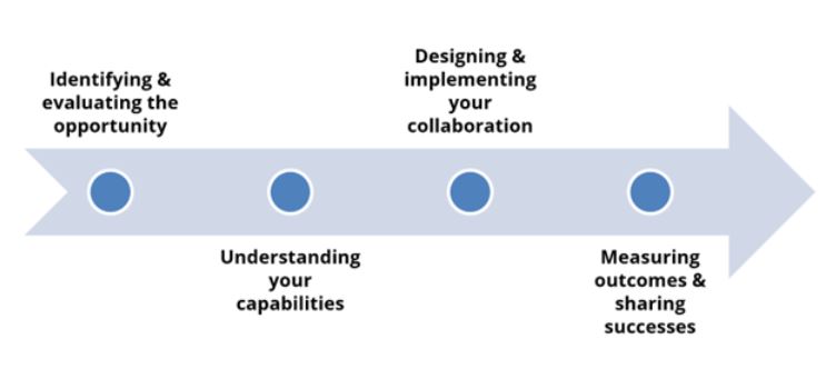
From the perspective of one or more municipal “champions” interested in initiating a collaboration to improve their geospatial capacity, there are several stages that they can expect to encounter, which comprise a ‘collaboration journey’ (Figure 1). These stages are as follows:
- Identifying and evaluating the opportunity;
- Understanding current capabilities;
- Designing and implementing the collaboration, and;
- Measuring outcomes and sharing successes.
Figure 1: Stages in the collaboration journey
At each of these stages, key questions and decision points have been identified based on interviews with municipal GIS staff, representatives from existing collaborations, and supporting organizations, and supplemented with findings from a broad-based literature review.
Stage 1: Identifying and evaluating the opportunity
What are the external and internal drivers of collaboration?
When municipal staff have identified one or more needs that cannot be solved internally, building a solid business case for collaboration is a first step.[10] Understanding the drivers — both external and internal — at play will help to build this case.
External drivers may present themselves in the form of broader trends (e.g., economic, social, or environmental) which require a multi-jurisdictional response, as well as the need to comply with specific mandates imposed by another level of government (see Box 1). Opportunities can also present themselves in the form of external funding availability, such as the Federation of Canadian Municipalities’ Green Municipal Fund and Municipal Asset Management Program, Infrastructure Canada’s Smart Cities Challenge, or programs administered by the provincial department or ministry overseeing municipal relations such as the Government of Ontario’s Municipal Modernization Program. Active participation in regional geomatics associations and user groups and municipal associations[11] can also serve as a means of keeping staff apprised of emerging opportunities for collaboration. External drivers may generate the momentum needed to move forward on initiatives that have been blocked up until this point.
Internal drivers could include digital transformation and other strategic initiatives that are already on a municipality’s agenda, in which case there may be an opportunity to advocate for improving geospatial data capacity in supporting or enhancing existing services, planning, and decision-making processes in the organization.[12] In practice, there is interplay between external and internal drivers; both must be taken into account in building a case that will convince multiple stakeholders (see Box 2).
Box 1: Next-Generation 911 (NG9-1-1) as an external driver
In an effort to modernize outdated 911 infrastructure across the country, the Canadian Radio-television and Telecommunications Commission (CRTC) issued a directive to telecommunications providers to implement Next-Generation 911 (NG9-1-1).[13] This directive mandates that communications service providers (CSPs) and incumbent local exchange carriers (ILECs) complete the transition to NG9-1-1 systems by June 30, 2024.
As opposed to legacy 911 systems based on tabular data, NG9-1-1 systems require several geospatial datasets for their functioning, including road centrelines and site/structure address points. Furthermore, this data must adhere to strict standards, such as those set out by the National Emergency Number Association (NENA, 2020). These datasets are typically collected and managed at the municipal level.
While the CRTC does not have jurisdiction over municipalities to compel them to provide the required data, telecommunications service providers (i.e., Bell, Rogers, SaskTel, Shaw, Telus) can require it as a condition of providing emergency telecommunications services to a municipality.
Since residents expect local emergency services to be provided to a high standard, municipalities have a strong incentive to consider the most efficient and effective way to make high-quality geospatial data available to telecommunications service providers. Collaboration through a spatial data infrastructure is one way to aggregate this data and ensure it meets NENA standards.
Box 2: Defining a strong business case
The YorkInfo Partnership – a collaboration involving York Region, its nine municipalities, two district school boards and two conservation authorities – took the step of documenting business cases for all of its major datasets, from critical infrastructure to street trees and building permits. These business cases outline the effort and time involved and articulate the value of sharing various types of data for the various business units inside each member organization as well as for the public and business community.[14]
For example, its NG9-1-1 business case highlights an “increase in resident safety” as the “key driver for integrating address points and the road network into the Data Co-op.”[15] Importantly, all the documented business cases are predicated on “a clear driving force, or demand in place for the business case to be a top priority.”[16] This is an excellent example of ensuring business cases for collaboration remain grounded in local priorities and context.
Who are potential partners?
The second component of creating a solid business case is identifying potential partners and what they can bring to the table. Of course, many municipalities will have a pre-existing relationship with their neighbouring jurisdictions. Regardless, a good first step is to establish contact with counterparts in neighbouring municipalities as a means of identifying shared challenges and gauging potential interest in collaboration.
In some cases, municipalities may be required to collaborate with their neighbours. For example, in 2018, the Province of Alberta passed legislation mandating inter-municipal collaborations for municipalities that share boundaries.[17] Smaller municipalities that share jurisdiction with an upper-tier municipality may have an advantage when it comes to collaboration since they have a built-in forum for bringing forward collaborative opportunities and challenges.
However, while smaller municipalities may be able to take advantage of larger municipalities’ capacity, they also face inherent power asymmetries that need to be navigated. In addition, although rural and remote municipalities may have fewer neighbours available to partner with, there may be an opportunity to collaborate with non-governmental partners – for example, Crown corporations, utilities or resource-based companies – provided that municipal staff exercise caution in negotiating with entities whose interests may not be aligned with their residents’ interests.
Finally, there is a need to consider what can be learned from previous collaborations in which the municipality may have been involved. Identifying existing strengths that can be built upon, as well as anticipating challenges that may be encountered, will help not only in setting realistic objectives but also in designing an appropriate governance structure for the collaboration (see Stage 3).
Questions for consideration
- What internal and external opportunities could be leveraged in favour of collaboration?
- What do potential partners have in common in terms of strategies around digital transformation, open government and open data?
- What can be learned from previous collaboration efforts?
Stage 2: Understanding current capabilities
Once an initial working relationship has been established between two or more municipalities, it is essential to get a better sense of the capabilities involved among the partners. Capabilities are the resources that enable actors to put motivation and opportunity into action. Knowing what capabilities are available to work with will help to put a realistic scope on the opportunities identified in the previous stage.
What human and technological resources are available?
A lack of trained staff is another common barrier[18] to realizing maximum value from geospatial information, as smaller municipalities may only have a single individual responsible for all their GIS needs (as well as supporting other IT needs). However, it may simply not be feasible to hire additional GIS staff on a permanent basis. In these cases, staff capacity could be supplemented by bringing in temporary support from the civic technology community (for example, through Code for Canada) or student interns (for example, through the Canada Summer Jobs program). However, the available pool of student labour will also depend on the community’s proximity to post-secondary institutions offering GIS programs.
Access to up-to-date GIS software is required in order to realize the greatest benefits from location-based data. There are a variety of products available, including locally-hosted and software-as-a-service (SaaS) cloud-hosted options, with modular feature sets that can be right-sized to municipal needs and available hardware. However, due to financial, technical or human resource capacity, it may not be feasible for all organizations – especially very small municipalities – to procure their own software. Additionally, in rural and remote areas, a lack of availability of broadband internet may be a barrier to fully implementing some network-based geospatial solutions.[19] Joint procurement in collaboration with neighbouring municipalities can help to defray some of the cost associated with modern GIS software packages. Open-source software is also available and may be a cost-effective but riskier option, as it may not come with access to technical support and may require more time and resources to set up and maintain properly.
What financial resources are available?
Limited financial resources are a reality for most municipalities. The desire to ‘do more with less’ (e.g., by creating economies-of-scale) may drive municipalities to seek collaboration with outside partners. Internally, champions of collaboration may be able to leverage more resources if the value proposition for collaboration (as discussed in Stage 1) is broad enough to create buy-in from multiple departments or business units and pool their respective budgets.
Externally, funding sources may be available that can support the establishment of a collaboration (e.g., hiring consultants to perform foundational data work, evaluating and procuring technology).[20] However, these funding sources may only be available as a one-time offering which cannot be relied upon to sustain a collaboration over time. Therefore, a basic financial contribution from each partner organization on an ongoing basis is not only necessary, but also creates a stake in the success of the collaboration.
What data assets are available?
Many organizations do not have a full picture of all the datasets they currently hold. By preparing an inventory of data holdings, municipal staff will be better positioned to identify gaps and determine how to go about addressing them. Starting with a previously defined business case, a data inventory can help partners in a collaboration better understand who has the relevant data, who needs it, and how it can be used to address the problem.[21]
A data inventory can also help to identify issues that may impact interoperability between partners’ datasets. For example, previous research found that practices related to the management of road network data (i.e., street centrelines) can differ substantially between municipalities in terms of which names, categories, tags, and attributes are used.[22] Where a desired use case has an established data standard associated with it, this can serve as a benchmark against which existing datasets can be evaluated and necessary alignment work can be planned.
Questions for consideration
- What datasets do each partner currently hold? What are the gaps and how might they be addressed?
- What GIS software is used by partners, if any? Does it have all the features needed to accomplish the objectives of the collaboration?
- Is there funding available to be committed to establishing and running the collaboration?
- How many full-time equivalent staff are trained to work geospatial data in each organization?
Stage 3: Designing and implementing the collaboration
What form should the collaboration take and how will it be governed?
Once two or more municipalities have decided that collaboration is the best course of action, staff must consider the most appropriate and feasible form of collaboration based on the intended use case. There is no ‘one-size-fits-all’ model for collaboration and its governance – each instance needs to be tailored to the local context.
In low intensity collaborations, consisting only of occasional exchange of datasets between partners through an open data portal, there may not be a need for a formal governance structure. If the collaboration will involve sharing of resources (e.g., human, technical, financial, administrative), it may require a more complex governance structure. There may be an obvious lead organization, such as if one municipality has substantially more developed geospatial capacity (see Box 3). However, it is important that all members – regardless of capacity – feel that they have influence in decision-making.
While some collaborations can exist informally, these can be vulnerable to differing interpretations or staff turnover. Therefore, it is desirable to formalize the terms in a document such as a memorandum of understanding (MOU) that clearly sets out expectations and specifies contributions from members.
Data sharing agreements can be used for data that – whether for technical or legal reasons – is less easily distributable such as ‘big data’ generated by intelligent transportation system technologies (e.g., video data from intersection sensors). A data-sharing agreement can specify the terms under which data held by one partner can be accessed by other partners. However, separate agreements can become time-consuming to navigate; it may be beneficial to explore a general-purpose agreement covering all datasets.
Box 3: A collaborative governance structure
The West Parry Sound Geography Network (WPSGN) formed in 2005 “to extend the benefits of GIS to neighbouring municipalities and maximize the return from pooled knowledge and resources” in the west side of the Parry Sound District.[23] The partnership was formalized through an MOU and is administered by one “lead” municipality – the Township of The Archipelago. Its operating budget is supported by all partners through membership fees, with operational resources managed by the lead municipality.[24] Today, all seven members have access to Esri’s ArcGIS platform, which supports various operations including 911 emergency response, planning and zoning, natural resources management, economic development, community engagement, public recreation and tourism.
What standards, processes, and procedures need to be adopted?
Interoperability is a critical success factor in geospatial collaborations. Therefore, staff must consider whether the technical infrastructure (software, hardware), data formats, data models, specifications, and workflows on which the collaboration is based are appropriate for the selected use case and are attainable by all partners.
Standards can provide guidance in this respect. In some use cases, the choice of standard will be clear: for example, the CRTC’s NG9-1-1 mandate requires that data conform to specifications set out by the National Emergency Number Association (NENA). In cases where partners have a choice in which standards they adopt, open standards such as General Transit Feed Specification (GTFS) or Open511 (for road events) should be considered since they can be used by anyone for free as opposed to proprietary standards which may involve a licensing fee to adopt.[25]
Maintaining high data quality is likely going to be a primary objective of any collaboration involving data. However, the definition of data quality will need to be collectively determined and will depend on the ultimate aim of the collaboration. Any processes and workflows that staff decide to implement within a collaboration should aim to strike a balance between ensuring data is fit-for-purpose while also being attainable so as not to create unnecessary barriers to participation. This includes providing adequate training to members, documenting all data standards, processes, and procedures, and making them easily available (see Box 4). This not only eases the burden on lower-capacity municipalities, but also allows for more efficient implementation within higher-capacity municipalities.
Box 4: Lowering barriers to participation
Data quality and interoperability are critical in a collaborative setting, but so too is striking the right balance between maintaining standards and facilitating participation. The Alberta Municipal Data Sharing Partnership (AMDSP), for example, requires from its members “a minimum of one update per year for each of the 3 layers within [a] municipality; Address Points, Roads and Common Places” in order to maintain current, high-quality data.[26] Detailed documentation on how to meet these and other specifications is available to all members.[27]
But what about data interoperability? How does the AMDSP create a seamless collective road network map when each of its members (over 200 as of 2022) may have slightly different local practices for representing spatial relationships between its geographic features?
The AMDSP’s solution is to use thousands of predefined ‘tie points’ in its Online Mapping System (AMOS) to make sure that all roads leaving each municipality connect to roads in the adjoining municipalities. These tie points allow each member to submit the data within their municipality without concern for ensuring that the road network is topologically correct, which saves them from undertaking the laborious process of correcting their entire dataset thus reducing a barrier to their participation.
Questions for consideration
- How is alignment around a common goal achieved?
- What processes might be required at the initiation stage of the collaboration versus the implementation and maintenance stages?
- How will contributions of various partners be governed (e.g., financial, staff, hardware)?
- How will the collaboration be formalized (e.g., using a data-sharing agreement, MOU, etc.)?
- What standard formats, models or schemas are most appropriate given the aims of the collaboration?
- Are there licensing restrictions on data that need to be accounted for?
- What processes and workflows need to be established?
Stage 4: Measuring outcomes and sharing successes
How will progress toward objectives be measured?
It is critical to set realistic objectives aligned with a larger goal when embarking on collaboration. A monitoring and evaluation framework will help partners with a collaboration to understand if it is meeting its objectives, both in terms of short-term and longer-term outcomes. The governance framework should have established formal processes for assessing progress, identifying gaps and making necessary course corrections.
There is a tendency to use as performance metrics those things that can be easily quantified (e.g., number of datasets shared, open data portal website hits). While these are useful up to a point, it is also important to track qualitative outcomes (see Box 5). If the collaboration involves a public-facing platform, periodic user surveys can be one source of qualitative insights. Regardless of the specific performance metrics used, it is important to look at them critically and understand their limitations.
Box 5: Tracking short and long-term outcomes
Beyond simple metrics, the YorkInfo Partnership also noted improvements in the following areas as a result of its collaborative Enterprise GIS initiative:[27]
- Goodwill and satisfaction in information products and services provided;
- Convenience through improved access to information and related services;
- Transparency leading to greater trust in the process and decisions;
- Situational awareness and better understanding of who’s doing what where;
- Improved public health and safety through better communications, and information access;
- Accountability and clarity in decision-making;
- Improved compliance through data standards, improved processes, and;
- Increased trust through partnership.
It is important to note that some of these outcomes may not manifest immediately, which underscores the importance of setting objectives with different time horizons as well as establishing monitoring and evaluation programs for collaborations that can track progress over time in addition to “quick wins.”
How can partners raise awareness of their collaboration?
It is important to raise awareness about how geospatial information is supporting residents’ needs – and how collaboration is making a difference. While staff may not see the value in communicating the outcomes of a geospatial collaboration beyond a small group of internal actors, telling a compelling story and demonstrating results can be instrumental in gaining buy-in from leadership and securing resources to sustain and grow the initiative.
Making some or all datasets compiled through the collaboration accessible through an open data portal can pay dividends in generating interest from the broader community. For example, the AMDSP’s datasets are “freely available through AMOS for reuse by governments, First Nations, citizens, voluntary organizations, academia and the private sector.”[28] Engaging different user bases in what the collaboration is doing – for example, opening data on request or developing customized applications based on partners’ combined data – signals responsiveness to community needs and improves trust in municipal government.
It is essential to document the development of the collaboration, not only to ensure continuity and knowledge transfer among the partners involved but also to mobilize accumulated knowledge outside the region.[29] By reflecting on outcomes that have been achieved, challenges that have been encountered, and lessons that have been learned, partners may also identify opportunities to strengthen the current value proposition and grow the collaboration (see Box 6). These opportunities could include scaling up collaboration to involve new partners or deepening the existing collaboration to support a wider range of municipal functions.
Box 6: Communicating success stories
In 2007, the AMDSP had only nine members; as of 2021, it counts around half of Alberta’s municipalities as members. After over a decade of tirelessly championing the partnership, the AMDSP’s leadership credits its success in recruiting new member municipalities to a couple of factors: a solid value proposition whereby members gain access to the shared platform along with support resources for an annual membership fee ranging from $0 to $200 based on the size of the municipality, along with the credibility gained from its peer-to-peer approach to collaboration. As a result of high levels of participation, the AMDSP is currently exploring the possibility of acting as an aggregator of NG9-1-1 data.[30]
Questions for consideration
- Which performance metrics will demonstrate that objectives have been achieved?
- How can the value of collaboration be continually demonstrated to municipal leadership, as well as residents?
- How can knowledge and lessons learned be shared with other communities?
Part 3: Conclusion and Recommendations
This report has presented an overview of the opportunity for collaboration to boost municipal geospatial capacity, by sharing data assets, infrastructure, and insights that an individual municipality would not otherwise be able to access. It has also surfaced a number of broad considerations and decision points for municipal staff at various stages of building a collaboration.
However, municipalities do not exist in a vacuum; there is a broader ecosystem in which various actors – provincial and regional governments, civil society actors, and the private sector – all play a role. This report concludes with recommendations for each of these groups for how they can support municipal geospatial capacity while promoting beneficial collaborations.
For provincial government actors
- Develop targeted grant and support programs for building municipal geospatial capacity. Support should be made available to individual municipalities as well as groups of municipalities in the form of training programs as well as start-up funding (e.g., for technical infrastructure). Support programs should incentivize the pooling of resources where feasible in order to maximize impact of funding, reduce duplication of efforts, and promote local autonomy;
- Invest in high-speed internet infrastructure for rural and remote communities. While not a strict prerequisite for collaboration, high-speed internet infrastructure enables a greater range of technologies that can support geospatial collaborations and other digital transformation initiatives.
For regional government actors
- Develop tailored support services, resources and funding opportunities aimed at developing capacity and supporting collaborative activities among lower-tier municipalities. These should complement rather than substitute for higher level government support, by bridging gaps and facilitating connections to specialized expertise to support municipal staff at various stages of their collaboration.
For civil society actors
- Convene forums and communities of practice for municipalities facing similar challenges. Municipal associations and other civil society organizations can facilitate periodic meetings of municipal actors, providing an opportunity for them to interact with one another and be exposed to new ideas and practices. However, while these occasional meetings may foster the development of trust and a shared vision, they may not directly lead to collaboration unless municipal actors are appropriately incentivized by higher tier governments;[31]
- Create partnerships with municipalities to facilitate mutual learning and capacity-building. Researchers from academic and non-profit sectors can partner with municipalities to engage in valuable knowledge co-creation activities, by bringing in relevant outside knowledge based on both research and practice, as well as documenting real-world collaborative processes and outcomes and mobilizing this knowledge throughout broader networks. Ideally these partnerships should be established prior to the initiation of a collaboration, and provision should be made for researchers to accompany municipal actors at each step of the process.
For private sector actors
- Develop tailored support services and products aimed at the small, rural, and remote municipal market: Promoting low-barrier solutions and interoperable applications will increase uptake from groups of municipalities with varying levels of geospatial capacity. Services such as Esri Canada’s Next Generation 911 Readiness Assessment can provide municipalities with an accurate picture of where they are, where they need to be, and how to get there.
- Demonstrate the value of making key datasets open and available from a public as well as commercial perspective: Identify and bring forward compelling use cases where collaboration between municipalities can support the local innovation ecosystem and provide public value at the same time.
Building municipal geospatial capacity – especially among smaller communities – through the creation of geospatial data collaborations is not only desirable but also necessary to tackle emerging issues such as climate change resilience, sustainable growth and mobility – as well as responses to public health events like the COVID-19 pandemic – that require collaboration well beyond the boundaries of any one municipality. Ultimately, there is still much to be learned about how municipalities can collaborate effectively and sustainably, and how non-municipal actors can best support them. It is hoped that the recommendations offered here will catalyze further conversation and research in this space.
Bibliography
Alberta. Municipal Affairs. “Implementation Fact Sheet: Intermunicipal Collaboration Frameworks,” 2017.
Alberta Municipal Data Sharing Partnership. “Become a Member.” AMDSP. Accessed November 17, 2021. https://amdsp.ca/become-a-member.html.
“NG9-1-1.” AMDSP. Accessed November 17, 2021. https://amdsp.ca/ng9-1-1.html.
“Open Data Policy.” AMDSP. Accessed November 17, 2021. https://amdsp.ca/open-data-policy.html.
“Specifications.” AMDSP. Accessed November 17, 2021. https://amdsp.ca/specifications.html.
Canadian Radio-television and Telecommunications Commission (CRTC). “Next-Generation 9-1-1.” Consumer information, January 16, 2017. https://crtc.gc.ca/eng/phone/911/gen.htm.
Chatwin, Merlin, and Jean-Noé Landry. “Making Cities Open by Default: Lessons from Open Data Pioneers.” Open Data Charter & Open North, February 2018. https://opennorth.ca/publications/2ce88qelsh6m30thifiniy_en.
Chatwin, Merlin, and John Mayne. “Improving Monitoring and Evaluation in the Civic Tech Ecosystem: Applying Contribution Analysis to Digital Transformation.” JeDEM – EJournal of EDemocracy and Open Government 12, no. 2 (December 18, 2020): 216–41. https://doi.org/10.29379/jedem.v12i2.598.
Elevon Solutions, LLC. “GIS Implementation Model For Small Jurisdictions A Case Study at the City of Hood River, OR,” 2016.
Evans, James, Tomáš Vácha, Henk Kok, and Kelly Watson. “How Cities Learn: From Experimentation to Transformation.” Urban Planning 6, no. 1 (March 26, 2021): 171–82. https://doi.org/10/gm32j7.
Johnson, Peter A, and Renee E Sieber. “Increasing Access to and Use of Geospatial Data by Municipal Government and Citizens: The Process of ‘Geomatization’ in Rural Québec” 25, no. 2 (2012): 8.
Johnson, Peter A., Renee Sieber, Teresa Scassa, Monica Stephens, and Pamela Robinson. “The Cost(s) of Geospatial Open Data.” Transactions in GIS 21, no. 3 (2017): 434–45. https://doi.org/10.1111/tgis.12283.
Landry, Jean-Noé, Peck Sangiambut, and Jury Konga. “Open Data Standards Pilot Project: Final Report.” MISA Ontario & Open North, June 2018. https://www.misa-asim.ca/resource/resmgr/ontario_documents/MISA_Ontario_Open_Data_Stand.pdf.
Municipal Capacity Development Program. “A Guide to Municipal Cooperation: Succeeding in Regional Partnerships,” 2010. https://sarm.ca/pub/departments/Resources/MCDP/Municipal%20Resources/Guides/a-guide-to-municipal-cooperation—succeeding-in-regional-partnerships.pdf.
Open Data Institute. “What are Open Standards for Data?” Open Standards for Data Guidebook, 2018. https://standards.theodi.org/introduction/what-are-open-standards-for-data/.
Pittaway, Jeffrey J., and Ali Reza Montazemi. “Know-How to Lead Digital Transformation: The Case of Local Governments.” Government Information Quarterly 37, no. 4 (October 2020): 101474. https://doi.org/10/ghjcwj.
Plunkett, Gordon. “How Do Collaborative Hierarchies Impact SDI Governance?,” October 12, 2020. https://resources.esri.ca/news-and-updates/how-do-collaborative-hierarchies-impact-sdi-governance.
“Make a Compelling Business Case for SDI Using These Building Blocks.” Esri Canada (blog), September 15, 2020. https://resources.esri.ca/covid-19-resource-library/make-a-compelling-business-case-for-sdi-using-these-building-blocks.
Spicer, Zachary. “Cooperation and Capacity: Inter-Municipal Agreements in Canada.” IMFG Papers on Municipal Finance and Governance, 2015.
The GovLab. “Designing a Data Collaborative – Phase 2: Supply.” Data Collaboratives. Accessed August 15, 2019. https://datacollaboratives.org/canvas.html#phase-2.
Township of Seguin. “Maps – GIS,” October 26, 2020. https://www.seguin.ca/en/explore-play/mapsgis.aspx.
Utah Community Development Office. “GIS Applications in Municipal Management: Strategies for Small Towns,” April 2021. https://cdotoolbox.files.wordpress.com/2021/04/gis_guide_4-8-2021_webversion.pdf.
Villeneuve, Joe. “Collaboration in GIS: The West Parry Sound Geography Network.” PowerPoint presented at the Exploring GIS Potential for Northwestern Ontario: A Panel Discussion with Successful Partnerships/Collaborations, Thunder Bay, Ontario, May 13, 2015. https://www.nwoinnovation.ca/upload/documents/west-parry-sound.pdf.
Yang, Tung-Mou, and Terrence A. Maxwell. “Information-Sharing in Public Organizations: A Literature Review of Interpersonal, Intra-Organizational and Inter-Organizational Success Factors.” Government Information Quarterly 28, no. 2 (April 2011): 164–75. https://doi.org/10.1016/j.giq.2010.06.008.
York Region. “Data and Analytics Success Playbook,” 2020.
“URISA ESIG Application 2015: Boldly Know York Region’s Enterprise GIS,” 2015.
YorkInfo Partnership. “BC00 – Sharing Data.” Data Co-op Business Cases, 2021. https://yorkinfopartnership.com/business-cases/.
“BC08 – NG 9-1-1.” Data Co-op Business Cases, 2021. https://yorkinfopartnership.com/business-cases/.
Endnotes
[1] Landry, Sangiambut, and Konga, “Open Data Standards Pilot Project: Final Report.”
[2] York Region, “Data and Analytics Success Playbook,” 11.
[3] Johnson and Sieber, “Increasing Access to and Use of Geospatial Data by Municipal Government and Citizens: The Process of ‘Geomatization’ in Rural Québec.”
[4] It is difficult to precisely define a mid-sized city. One definition that considers cities with 50,000 to 500,000 residents as mid-sized cities is drawn from Sotomayor, Luisa, and Jo Flatt. “At a Turning Point: A New Era for Mid-Sized Cities.” In Leveraging Ontario’s Urban Potential: Mid-Sized Cities Research Series, edited by Evergreen Mid-Sized Cities Research Collaborative, 3–12, 2017. https://www.evergreen.ca/downloads/pdfs/2017/00_MSC_RC_Compendium.pdf.
[5] Utah Community Development Office, “GIS Applications in Municipal Management: Strategies for Small Towns.”
[6] Spicer, “Cooperation and Capacity: Inter-Municipal Agreements in Canada.”
[7] Municipal Capacity Development Program, “A Guide to Municipal Cooperation: Succeeding in Regional Partnerships.”
[8] Chatwin and Landry, “Making Cities Open by Default: Lessons from Open Data Pioneers.”
[9] Johnson et al., “The Cost(s) of Geospatial Open Data.”
[10] Plunkett, “Make a Compelling Business Case for SDI Using These Building Blocks.”
[11] These can include general purpose municipal associations such as the Association of Municipalities of Ontario (AMO) or organizations with a specific focus such as the Municipal Information Systems Association (MISA).
[12] Plunkett, “How Do Collaborative Hierarchies Impact SDI Governance?”
[13] Canadian Radio-television and Telecommunications Commission (CRTC), “Next-Generation 9-1-1.”
[14] YorkInfo Partnership, “BC00 – Sharing Data.”
[15] YorkInfo Partnership, “BC08 – NG 9-1-1.”
[16] YorkInfo Partnership, “BC00 – Sharing Data.”
[17] Alberta. Municipal Affairs, “Implementation Fact Sheet: Intermunicipal Collaboration Frameworks.”
[18] Yang and Maxwell, “Information-Sharing in Public Organizations.”
[19] Communities interested in moving forward with a broadband internet strategy can explore resources such as the Getting Started with Community Broadband toolkit, developed by Evergreen.
[20] Elevon Solutions, LLC, “GIS Implementation Model For Small Jurisdictions A Case Study at the City of Hood River, OR.”
[21] The GovLab, “Designing a Data Collaborative – Phase 2: Supply.”
[22] Landry, Sangiambut, and Konga, “Open Data Standards Pilot Project: Final Report.”
[23] Township of Seguin, “Maps – GIS.”
[24] Villeneuve, “Collaboration in GIS: The West Parry Sound Geography Network.”
[25] Open Data Institute, “What are Open Standards for Data?”
[26] Alberta Municipal Data Sharing Partnership, “Become a Member.”
[27] York Region, “URISA ESIG Application 2015: Boldly Know York Region’s Enterprise GIS.”
[28] Alberta Municipal Data Sharing Partnership, “Open Data Policy.”
[29] Evans et al., “How Cities Learn.”
[30] Alberta Municipal Data Sharing Partnership, “NG9-1-1.”
[31] Pittaway and Montazemi, “Know-How to Lead Digital Transformation.”